Thursday, 24 April 2025

Kosmos 482 Descent Craft reentry forecasts [PERIODICALLY UPDATED]

Click diagram to enlarge


Last update: 11 May 2025 10:15 UTC 
 
(this post is being periodically updated with new reentry forecasts/postcasts)
 
* The last TUDAT nominal forecast is reentry on 10 May 2025, 6:39 UTC ± 1.5 hr *
* The TUDAT nominal postcast is reentry on 10 May 2025, 6:40 UTC ± 1.5 hr *


In the second week of May 2025, an unusual object reentered. It concerns the Kosmos 482 Descent Craft (1972-023E, cat. nr. 6073).

This object is the lander module from a 1972 failed Soviet Venera mission to Venus. Because of a failure of the upper stage of the rocket that launched it, it got stuck in a very elliptical orbit around Earth in 1972, instead of going to Venus. 
 
I published an extensive discussion and analysis of this object and its history three years ago in The Space Review. The identification of this object as the lander module was initially suggested by Jonathan McDowell (see his brief interesting history here).

Recently declassified Russian historic documents unearthed by Anatoly Zak point out that after failure to get to a heliocentric orbit, the lander was deliberately separated from the main bus by the spacecraft operators. My analysis published in 2022 suggests that this happened in June 1972. The lander is encased in a semi-spherical shaped Titanium protective shell, a kind of rounded metal bucket so you will (see image below).

As this is a lander that was designed to survive passage through the Venus atmosphere, it is possible that it will survive reentry through the Earth atmosphere intact, and impact intact. It likely will be a hard impact: I doubt the parachute deployment system will still work after 53 years and with dead batteries. There are many uncertain factors in whether the lander will survive reentry though, including that this will be a long shallow reentry trajectory, and the age of the object.
 
 
Venera 7 lander mock-up. The Kosmos 482 Descent Craft is probably similar. Photo: NASA

 
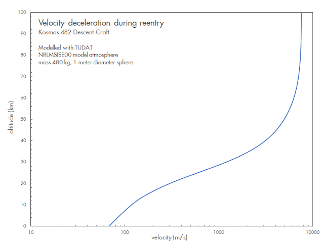
The risks involved are not particularly high, but not zero: with a mass of just under 500 kg and 1-meter size, risks are somewhat similar to that of a meteorite impact. A TUDAT reentry analysis to ground level suggests an impact speed (after atmospheric deceleration) of about  65-70 meter per second (~242 km/h), assuming the reentering lander did not break up or extensively ablate during reentry (see the diagram below: note the logarithmic scale of the x-axis). The kinetic energy at impact is similar to that of a 40-55 cm large (after ablation) meteorite fragment. As it will likely reach earth surface as only one single object, the risks involved are lower than for example those created by a Falcon 9 upper stage reentry, which showers multiple meter-sized objects over a large area (as we saw recently with the impact of Falcon 9 remains in Poland).
 
Click diagram to enlarge

 
The diagrams below shows the change in altitude of apogee and perigee over the past 1.5 years and the past 4 months: notably apogee has been coming down steadily, but in the past few months, perigee has started to come down too. Early May 10 around 00:35 UTC, the object was in a 166 x 120 km orbit, with apogee coming down by 70 km/day and perigee by 25 km/day (and these values increasing each day, see diagram below).
 
Click diagram to enlarge

 
Click diagrams to enlarge

 
The reentry is an uncontrolled reentry. Even close to reeentry, we cannot say with any degree of certainty when and where the Kosmos 482 Descent Craft exactly will reenter.

With an orbital inclination of 51.95 degrees [note: I initially erroneously stated 51.7 here], the reentry can occur  between latitude 52 N and 52 S.

Over the past months, together with my colleague Dominic Dirkx,  we have been developing a reentry model for this object in TUDAT.
 
TUDAT, the TU Delft Astrodynamics Toolbox is open source, multi-platform Astrodynamics software developed and maintained at the Aerospace faculty of Delft University of Technology (TU Delft) in the Netherlands (where I work). The TUDAT script we use for our analysis is here, while the TUDAT software itself is available here.
 
The Kosmos 482 Descent Craft is probably similar to the descent craft of Venera 8 (which was launched only a few days earlier in 1972). Literature values suggest that the object is about 1 meter in size and semi-spherical, with a mass of ~495 kg. 
 
Using our TUDAT model and a 1-meter diameter, and the NRLMSISE00 model atmosphere with historic space weather data, we find that the orbital evolution of  the object from mid-1972 to early 2025 is actually best matched when we use a mass of 480 kg, 15 kg less than the literature value. All our forecast predictions are therefore done using a mass of 480 kg. 
 
For our forecasts we employ the NRLMSISE00 model atmosphere, and historic spaceweather data plus estimated future space weather (solar flux). Orbit updates for each run are sourced from the US Military tracking network CSpOC (so as a note: our forecasts are not based on our own tracking data. They are based on our own custom reentry model developed at Delft University of Technology, with external tracking data from CSpOC as input).

 
Click diagram to enlarge

The diagrams in top of this post and below (which I will periodically update) give the evolution of our reentry predictions, based on orbits issued for the object since November 2024. Over the past half year, the model has consistently pointed to reentry within a few days of 9-10 May 2025. 
 
The latest nominal forecasts currently center on early May 10, but are still fluctuating with each orbital update. Early May, there was a short-lived tendency in the model runs of a shift towards a later time of reentry (i.e. May 11 rather than May 10), as can be seen in the below diagrams and the table near the end of this post. But lately, the new forecast runs have been returning to nominally May 10. 
 
 
Click diagram to enlarge
 
Click diagram to enlarge
 

The brief shift towards a later date in the early May model runs was due to space weather forecasts underestimating future solar activity at that time. I had started to note this (when comparing earlier forecast solar flux values to actual solar flux values for the last days of April  and the first days of May) and already expected the nominal forecasts to return to May 10, as they now indeed have done.
 
This highlights the influence of uncertainties in estimated future solar activity on the forecasts. Future solar activity is not well predictable. Even the best reentry models will be off in their forecast if actual solar activity in the window between the moment of forecast and the moment of reentry develops differently than the predictions. Solar flux variations are an important driving factor of short-term variations in density and extent of the upper atmosphere. The latter determine how many drag the object experiences over its orbit, and with that how quick the orbit decays. Stronger solar activity will mean an earlier reentry, lower solar activity a later reentry.
 
Of course, at this point the uncertainty in the forecast is still +/- 1.5 hours. Yet, the uncertainty window has now decreased to the point that we can rule out certain parts of the world: Africa is safe. So is Japan, East Asia, and the USA.
 
The map below gives the trajectory of the object over the current uncertainty window of the TUDAT reentry forecast (red dots are cities with over 1 million inhabitants, between latitude 52 N and 52 S). In our model the spacecraft could have reentered anywhere along the blue line:
 
Click map to enlarge
 
 
CSpOC, the US military tracking network, has started to provide TIP (Time of Impact Prediction) messages for the object since May 6. They are depicted as red circles in the diagram earlier in this post.
 
The last orbit update published by CSpOC has epoch 10 May 2025, 00:36 UTC, i.e. dates from about 6 hours before the time we think it actually reentered. There are later radar detections from Europe, per ESA, dating to as late as 6:04 UTC, but no orbit based on that has been published.

A roundup of current reentry forecasts from various sources (each running their own reentry model) compiled 10 May 15:30 UTC:
 
TUDAT forecast:              10 May   06:39 ± 91  min UTC
TUDAT postcast:              10 May   06:40 ± 91  min UTC
Aerospace Corp forecast:     10 May   06:29 ± 120 min UTC
RosCosmos postcast:          10 May   06:24 ± ?   min UTC
ESA postcast:                10 May   06:16 ± 22  min UTC
EU-SST forecast:             10 May   06:04 ± 20  min UTC
CSpOC TIP postcast:          10 May   05:32 ± 12  min UTC *
 
* this cannot be correct given that a positive radar detection from Germany at 6:04 UTC was reported by ESA.
 
note: forecast = issued before the reentry; postcast = issued after the reentry after re-analysis.
 
ESA reports that they had a positive radar detection of the spacecraft, still on-orbit, at 6:04 UTC while it was passing over Germany (presumably with the TIRA radar); and a negative detection one orbital revolution later, at 7:32 UTC. This implies reentry during the window 6:04 - 7:32 UTC. Five of the forecasts fall in that window: our TUDAT forecast, and those by RosCosmos, ESA, the Aerospace Corporation, and also EU-SST when taking the error margins on the latter into account.
 
Roscosmos, the Russian Space Agency, on Telegram states reentry at "6:24 UTC" over the Indian Ocean. That is not too far (15 minutes) from our latest TUDAT model results. Three remarks: (1) this is not a reentry detection but likely another model result (just as the others), based on an earlier groundbased detection during a pass over presumably southern Russia. (2) It does not come with a stated uncertainty window: is that 10 minutes, 30 minutes, an hour? (3) It remains a question how serious one should take Russian State statements these days as sometimes pragmatic considerations (such as deliberate denial of responsibility or risk) are leading. 
 
While many news media seem to treat the RosCosmos announcement as 'authoritive' and the 'most accurate' or 'final' say on the matter, there is in reality no clear reason to do so. It is not clear at all whether the RosCosmos position is more accurate than the other model estimates, and how meaningful the stated positions and time are given the lack of error margin information.

A final accurate TIP from CSpOC has not yet appeared (and might not appear if they have no space-based detections of the reentry fireball). CSpOC sometimes, several hours to a day after a reentry, publishes a very accurate (with quoted +- 1 minute uncertainty) final TIP which Jonathan McDowell and I believe is not based on a reentry model, but on space-based (SBIRS satellite) detections of the reentry fireball, hence the accuracy. They have not issued such a TIP so far for this reentry, unfortunately. Note that their last issued TIP cannot be correct, given the reported positive radar detection of the spacecraft passing over Germany at 6:04 UTC.
 
This is how the nominal reentry points have been placed by various organisations, each based on their own modelling:
 
Click map to enlarge

 
It is clear that the assessments spread. Ignoring the clearly incorrect CSpOC TIP, the other models all suggest reentry over either southwest Asia or the Indian Ocean. My verdict is that the latter area is the most likely place.
 
Below is the evolution of the reentry forecast from our TU Delft TUDAT model in tabular form, latest forecast at the bottom. Please take note of the uncertainty values listed in the last column!
 
The 'postcast' value is a re-run of the model after-the-fact based on the last published orbit and the actual rather than estimated space weather of May 10.
 

--------------------------------------------------------------------
TUDAT REENTRY FORECAST EVOLUTION for KOSMOS 482 Descent Craft
M. Langbroek & D. Dirkx, Delft University of Technology

Date/times in UTC

REFERENCE ORBIT    ORBIT EPOCH      REENTRY FORECAST   +/-   
----------------------------------------------------------------
15-11-2024 05:43   24320.23870400   05-05-2025 23:33   42.9 days   
01-12-2024 05:32   24336.23116452   08-05-2025 09:09   39.5 days   
15-12-2024 18:58   24350.79080401   07-05-2025 11:51   35.7 days   
01-01-2025 11:20   25001.47260254   09-05-2025 07:20   32.0 days   
15-01-2025 03:23   25015.14140884   10-05-2025 20:40   28.9 days   
02-02-2025 08:54   25033.37115746   13-05-2025 17:52   25.1 days   
15-02-2025 03:20   25046.13941015   11-05-2025 09:52   21.3 days   
01-03-2025 00:07   25060.00535989   10-05-2025 17:51   17.7 days   
15-03-2025 05:56   25074.24770046   10-05-2025 07:57   14.0 days   
30-03-2025 12:05   25089.50360681   09-05-2025 21:11   10.1 days   
13-04-2025 21:32   25103.89775709   09-05-2025 22:01    6.5 days   
20-04-2025 01:39   25110.06916305   09-05-2025 11:31    4.9 days   
22-04-2025 21:24   25112.89204293   09-05-2025 12:48    4.2 days   
23-04-2025 22:57   25113.95657237   09-05-2025 19:43    4.0 days   
27-04-2025 00:27   25117.01893077   10-05-2025 04:52    3.3 days   
28-04-2025 00:24   25118.01685903   10-05-2025 06:33    3.1 days   
28-04-2025 22:50   25118.95143786   10-05-2025 06:01    2.8 days   
01-05-2025 20:57   25121.87323063   10-05-2025 14:30    2.2 days   
02-05-2025 09:12   25122.38386703   11-05-2025 02:36    2.2 days   
02-05-2025 12:16   25122.51167762   11-05-2025 03:41    2.2 days   
02-05-2025 17:52   25122.74476620   11-05-2025 06:50    2.1 days   
03-05-2025 18:07   25123.75533175   10-05-2025 20:48    1.8 days   
03-05-2025 21:05   25123.87876286   10-05-2025 23:06    1.8 days   
04-05-2025 20:47   25124.86648285   10-05-2025 19:05    1.5 days   
05-05-2025 20:29   25125.85361170   10-05-2025 07:26    1.1 days   
06-05-2025 09:39   25126.40254557   10-05-2025 08:37    1.0 day
06-05-2025 21:26   25126.89335737   10-05-2025 07:51   20.6 hr
07-05-2025 21:00   25127.87559184   10-05-2025 07:34   14.6 hr
08-05-2025 11:31   25128.48053679   10-05-2025 07:24   11.0 hr
08-05-2025 13:13   25128.55136979   10-05-2025 07:34   10.6 hr
08-05-2025 19:13   25128.80083450   10-05-2025 07:54    9.2 hr
09-05-2025 12:37   25129.52575525   10-05-2025 06:23    4.4 hr
09-05-2025 14:12   25129.59226104   10-05-2025 06:30    4.1 hr
09-05-2025 15:43   25129.65543839   10-05-2025 06:35    3.7 hr
09-05-2025 19:55   25129.82989846   10-05-2025 06:34    2.7 hr
10-05-2025 00:35   25130.02495443   10-05-2025 06:39    1.5 hr

                               nominal location 35.7 S 126.5 E

POSTCAST:

10-05-2025 00:35   25130.02495443   10-05-2025 06:40    1.5 hr

                               nominal location 38.0 S 129.8 E


I will periodically update this table with new forecasts, more frequently so when the reentry dates comes nearer.

Here is footage I shot of the Kosmos 482 Descent Craft with my tracking camera in Leiden, in 2020:


An added note: about that parachute....

To muddy the waters further, a story is spreading that the parachute of the landing craft might already have deployed in space. This is based on telescopic imagery purportedly showing this.

I have strong doubts that the imagery in question shows any meaningful detail. The imagery has the same origin, and the same problems attached, as the imagery I discussed in 2022 in my Space Review article. I think the "detail" is the result of camera/telescope shake and atmospheric distortion.

This post has been updated with new forecasts and additional background information several times

Friday, 4 April 2025

Observing FRAM-2, a commercial crewed Dragon mission in Polar orbit

Click image to enlarge

The image above is a stack of twelve 4-second exposures taken with a Canon EOS 80D and EF 2.8/24 mm lens, and shows the Crew Dragon FRAM-2 passing over the domes of the historic Leiden Observatory in the evening of 2 April 2025.

FRAM-2 is a commercial ("space tourist") mission using a SpaceX Crew Dragon launched into a 90.0-degree inclined Polar Orbit at approximately 430 km altitude. It is the highest inclination of any crewed space mission so far. The spacecraft has four astronauts onboard: Chun Wang, Jannicke Mikkelsen, Rabea Rogge and Eric Philips.

click image to enlarge

I observed the spacecraft on April 2 and 3, 2025. On April 2, on a 35-degree elevation evening twilight pass in the east, it reached magnitude +2.5 to +2.0. On April 3, on a high pass in the west, it was fainter, around +3.5 to +4.

Here is a single image from the series I shot on April 2 (4-second exposure at ISO 800):

Click image to enlarge


Below image is from the April 3 pass and shows both FRAM-2 and two Chinese satellites, as well as an unidentified object in a 49-50 degree orbit (possibly a Starlink or Starshield satellite). The "smudge" in the image is a lens reflection caused by the nearby moon:


Click image to enlarge

Here is a stack of 10 images from April 3:

Click image to enlarge

Thursday, 27 March 2025

USA 498, the NROL-69 payload, found

click map to enlarge

On 24 March 2025 at 17:48 UTC, a Falcon 9 blasted off from Cape Canaveral launch pad 40 in Florida as NROL-69, carrying the classified USA 498 payload to orbit for the National Reconnaissance Office (NRO).

About two hours later, the launch caused a spectacle in the skies over Europe, as a bright spiral-shaped cloud formed in the sky, moving along the track of the Falcon 9 upper stage from the launch. This was due to the Falcon 9 upper stage venting excess fuel, in preparation for reentry over the Indian Ocean about half an hour later, following a deorbit burn over the northern Atlantic. 

The cloud of fuel droplets vented by the rocket stage was at an altitude of about 1000 km, where it was still in sunlight, causing it to shine brightly in the sky. The spiral pattern is due to the rocket stage spinning around is major axis, in order to stabilize the orientation of the stage in space. This is very typical for Falcon 9 upper stages and has been seen quite a few times now.


Prior to launch, Navigational Warnings seemed to indicate an initial launch into a 51-52 degree inclined orbit for NROL-69, followed by a burn into an approximately 64.4 degree inclined orbit

Initially I interpreted the trajectory as featuring a 'dogleg' manoeuver into 64.4 degree inclination just after launch. I later revised that, following reports from observers in Poland that they saw the Falcon 9 during its first pass over Europe, 25 minutes after launch, in a trajectory more consistent with still being in a 51-52 degree inclination orbit. In addition, reports came from western Australia about a possible remnant exhaust cloud that might have been seen there about an hour after launch. 

I therefore revised my interpretation of the launch sequence. My revised interpretation features an initial insertion into a 51-52 degree coasting orbit, followed by an insertion burn into 64 degrees inclination near the ascending node, about an hour after launch, over the Indian Ocean near western Australia. Following that, and following orbit insertion of the payload, the deorbit burn for the Falcon 9 upper stage happened over the northern Atlantic just after completion of the first revolution, and next the fuel venting seen from Europe around 20 UTC (21 CET), some two hours after the launch, during the first part of the second revolution. Deorbit of the Falcon 9 was around 20:40 UTC, 1.5 revolutions after the launch, over the Indian Ocean southeast of Madagascar (see map in top of this post).

Below are the Navigational Warnings for the launch. The hazard areas from these warninsg are plotted in red in the map in top of this post.

191844Z MAR 25
NAVAREA IV 332/25(11,26).
WESTERN NORTH ATLANTIC.
FLORIDA.
1. HAZARDOUS OPERATIONS, ROCKET LAUNCHING
   241742Z TO 241824Z MAR, ALTERNATE
   251728Z TO 251810Z, 261714Z TO 261756Z,
   271700Z TO 271742Z, 281646Z TO 281728Z,
   291632Z TO 291714Z AND 301618Z TO 301700Z MAR
   IN AREAS BOUND BY:
   A. 28-38.31N 080-37.17W, 28-51.00N 080-14.00W,
      28-44.00N 080-03.00W, 28-30.00N 080-18.00W,
      28-27.40N 080-31.49W.
   B. 30-14.00N 078-53.00W, 31-58.00N 077-03.00W,
      32-18.00N 076-17.00W, 32-02.00N 075-57.00W,
      31-15.00N 076-21.00W, 29-55.00N 078-35.00W.
2. CANCEL THIS MSG 301800Z MAR 25.

190258Z MAR 25
HYDROPAC 711/25(61).
INDIAN OCEAN.
DNC 02, DNC 03.
1. HAZARDOUS OPERATIONS, SPACE DEBRIS
   1849Z TO 2058Z DAILY 24 THRU 30 MAR
   IN AREA BOUND BY
   23-06.00S 060-45.00E, 24-22.00S 058-21.00E,
   54-18.00S 084-05.00E, 53-02.00S 087-47.00E.
2. CANCEL THIS MSG 302158Z MAR 25.//

As 64.4 degrees is the typical inclination for a NOSS (Naval Ocean Surveillance System) duo of SIGINT satellites, and given the location and timing of the deorbit area for the upper stage, my initial suspicion was that this could be a new NOSS launch into a 900 x 1300 km 64.4 degree inclined orbit. I was wrong in this however.

Two days after the launch, in the evening of March 26, a number of European observers (Tomi Simola in Finland, Eelke Visser and me in the Netherlands, and David Brearley in the UK) managed to find the payload on-orbit, close to my search orbit. Only one object could be detected, indicating that it is not a NOSS but something else. Below is a stack of several video frames showing the object (video itself is at the end of this post):

click to enlarge

The payload, now named USA 498, was detected in a 64.1 degree inclined, ~700 x 1500 km orbit (but this is based on a very short arc so the exact orbital altitude is still up for revision). We have not seen something in this kind of orbit earlier, apart from NOSS satellites (the closest in orbital similarity otherwise is USA 327 (2022-040A), in a 1076 x 1135 km 63.4 degree inclined orbit).

The plot below shows its orbit and orbital position for the time of my March 26 observation: 


Click image to enlarge

Below is some of my video footage from March 26, showing the payload as an object of about magnitude +5 to +6 (the instrument was a WATEC 902H2 Supreme with 1.2/50 mm lens):


Preliminary orbit (McCants):

USA 498 (NROL-69)
1 63350U 25060A   25085.82507109 0.00000000  00000-0  00000-0 0    05
2 63350  64.0600 349.1636 0555412  27.6298 328.1938 13.37020084    05

Friday, 14 March 2025

The Russian eavesdropping satellite LUCH (OLYMP-K) 2 has moved significantly

click diagram to enlarge

I have written before on this blog about the Russian military SIGINT satellite LUCH (OLYMP-K) 2 (2023-031A). It was launched  on 12 March 2023, and like its predecessor LUCH (OLYMP-K) 1, it has since moved about along the geostationary belt, doing proximity operations near western commercial geostationary satellites. 

Each two to four months, it is moved to a new target, where it stays in close proximity until moved to a new target again, behaviour in a similar fashion to the US satellite PAN/NEMESIS-1 in the past. It is probably clandestinely accessing and monitoring communication streams of the target satellites, and perhaps mapping contact networks. It can sometimes come very close to its target, to within a few to a few tens of kilometers (that is very close in space).

From September 2024 onwards it was positioned at 0.93 W close to Intelsat 1002, but on February 7, 2025, it started a drift eastwards. After a significant one-month drift over 62 degrees in longitude, it settled again on March 7 near 62 E, its new eavesdropping target being Intelsat 39 (2029-049B). This latest move is the largest since it was launched.

Due to a combination of flu, moonlight and the fact that the new position is barely above the eastern horizon for me, I have not been able to image it in its new position yet.

The diagram above shows the various repositionings of LUCH (OLYMP-K) 2 since it was launched. Since launch, it has taken up the following positions:

PERIOD                     LONG.      NEAR
21-03-2023  24-03-2023     78.00 E    (checkout) 
07-04-2023  02-05-2023     58.00 E    (checkout) 
22-05-2023  25-09-2023      9.00 E    EUTELSAT (KA SAT) 9A, EUTELSAT 9B
04-10-2023  04-12-2023      3.20 E    EUTELSATt 3B
05-12-2023  26-03-2024      2.60 E    EUTELSAT KONNECT VHTS
01-04-2024  22-06-2024      4.75 E    ASTRA 4A
01-07-2024  16-09-2024      0.54 W    THOR 7
18-09-2024  07-02-2025      0.92 W    INTELSAT 1002
07-03-2025                 62.02 E    INTELSAT 39

Wednesday, 19 February 2025

The reentry of a Falcon 9 upper stage over NW Europe on 19 February [UPDATED]


In the early morning of February 19, 2025, near 3:45 UTC (4:45 CET) scores of people in the Netherlands, UK, Germany and Denmark saw a slow, fragmenting object move through the sky. The event garnered much attention. 

Above is a video of the event obtained by the camera of @dutchspace.bsky.social in the Netherlands.  Another stunning video, by the meteor camera of André Knoeffel in Brandenburg, Germany, is here. The video below is by Nick James from the UK, and shows the start of the reentry near 03:43 UTC and start of fragmentation.


The event was caused by the reentry of a SpaceX Falcon 9 upper stage, object 2025-022Y (cat nr 62878) . This upper stage, from the Starlink group 11-4 launch from Vandenberg, California, on 1 February 2025 23:02 UTC, 18 days prior to the reentry event, failed to deorbit in a controlled way after launch and payload insertion. It was supposed to do a deorbit burn after releasing the payloads, and deorbit over a specified area in the Pacific Ocean around 00:45 UTC on Feb 2, near the end of the first revolution (see map below). With the deorbit failed, it however stayed on orbit for almost 3 weeks, and then had an uncontrolled deorbit over NW Europe on February 19.


click map to enlarge

The general character of the Feb 19 event (slow, fragmenting) as well as time and location fit well with the Falcon 9 upper stage reentry. The CSpOC final TIP for this reentry (which we suspect is based on a satellite observation of the reentry fireball) is 19 February 3:43 UTC ± 1 min, near 52.8 N, 5.6 W. The reentry trajectory runs over the British Isles, the northern Netherlands, northern Germany and Poland.

Below is the ground-track for the last orbit up to reentry, and a detail of the approximate final reentry track over Europe, with the Netherlands indicated in red:

click map to enlarge

 
click map to enlarge

A possible piece of debris has been found at Komorniki near Poznan in Poland, media reports. The object on the photograph looks like a Composite Overwrap Pressure Vessel, a component of the Falcon 9 upper stage that has survived reentry before, e.g. in March 2021 when a Falcon 9 upper stage reentered over Washington. The location of the find matches well with the reentry trajectory, as can be seen in the map above. [update: reportedly another one of these composite-wrapped pressure tanks was subsequently found in Poland]

The event caused a lot of media attention: I did several media interviews on the reentry, amongst others with two Dutch national tv channels.


Friday, 31 January 2025

The North Korean satellite Malligyong-1 manoeuvered again, and this time it is different

click diagram to enlarge


In two contributions to The Space Review (part 1 here and part 2 here) for the first instance, as well as two follow-up blog posts for later manoeuvers (here, and here), I analyzed three periodic orbit raising manoeuvers by the North Korean military reconnaissance satellite Malligyong-1 (2023-179A) done in February, June and September 2024. They followed a similar pattern: an orbit raise (orbit maintenance manoeuver) in five daily increments, all taking place on late evening passes (13 - 14h UTC = 22 - 23h local time) passes over North Korea.

Now Malligyong-1 has manoeuvered for a fourth time. And while there are some similarities, this time the followed pattern was different.

The orbit raising manoeuver was done between 2025 January 16 and 18, a month later than I had anticipated. However, as can be seen in the diagram above, it was this time done in three daily increments, not five as was the case in previous orbit raising events. 

Compared to the previous orbit raises, the raise during each daily increment was larger, some 2.5 km per increment rather than 1.2 km as in the previous cases, for a total orbital altitude raise of about 7.5 km, which is also somewhat larger than the previous orbit raises (which was 4 km in February 2024 and 6 km in June and September 2024). As during the previous orbital altitude maintenance raises, it brought back the orbital altitude to the initial value from November 2023, when the satellite was launched. See the diagrams below:

click diagram to enlarge

The three sequential manoeuvers between January 16 and 18 raised both apogee and perigee. The daily rate of RAAN precession is still very close to the ideal sun-synchronous value.

click diagram to enlarge

As was the case for all previous orbit raises, the times I reconstruct for the three incremental orbit raises correspond to the orbital plane of Malligyong-1 passing over or near North Korea (for the method used, see here);

#   DATE       UTC    LAT     LON      ORBITS USED FOR ANALYSIS          RAISE
M1  16-01-2025 13:14  28.6 N  53.4 W   25016.48110101  25017.33556354    2.50 km
M2  17-01-2025 12:52  19.4 N  46.3 W   25017.33556354  25018.12465384    2.51 km
M3  18-01-2025 12:33  20.5 N  41.7 W   25018.45348685  25019.24307946    2.52 km


However, there is a clear difference: all nominal positions do not plot near North Korea this time, but over the mid-Atlantic. Nominal manoeuver times were about half an hour before passing over/near North Korea.

The map below plots the nominal manoeuver positions I reconstruct, as well as a part of the ground trajectory from 10 minutes before to ten minutes after the nominal reconstructed manoeuver time.

click map to enlarge

The red circle in the map is the area where the satellite would be above the horizon as seen from Pyongyang. Clearly - and unlike previous occasions - the manoeuver points do not coincide with this area, although the satellite would pass through the area about 30 minutes after the reconstructed manoeuver moments (for one of the manoeuver moments, I depicted a longer part of the ground trajectory as well with markers each 5 minutes of flight time).

The manoeuvers not conciding with the satellite being over the horizon as seen from the Pyongyang General Satellite Control Center (PGSC), is something new and intriguing. The nominal manoeuver points being over the mid-Atlantic is interesting. 

So how where these manoeuvers initiated? Assuming my reconstruction of the manoeuver points is correct, here are three options, all having their own implications:

(1) use of a pre-programmed, automated orbit raising burn;

(2) an orbit raising burn command sent through a (Russian? Chinese?) relay satellite in GEO;

(3) an orbit raising burn command sent from a groundstation or ship near/around the mid-Atlantic.

The white area depicted in the map is from where a command from a ground station or ship should have been sent in the case of option (3), possibly a location in Brazil or the mid-Atlantic. 

It might be interesting if someone better versed in that than me, could check the presence of North Korean vessels (and Russian and Chinese space tracking vessels) in the mid-Atlantic between January 16 and 18, 2025.

All three nominal positions correspond to a manoeuver just after passing through the Ascending Node, which is often a standard practise with orbit raising manoeuvers when smaller or larger alterations to the orbital inclination are required. However, no such alterations to the orbital inclination are apparent:

click diagram to enlarge

This was the fourth orbit rasing manoeuver episode since Malligyong-1 was launched on 21 November 2023. Here are they all in a table:

#  period           incr    raise    before  after    interval
1  2024 19-23 Feb    5x     4.0 km   498 km  502 km   90  days
2  2024 03-07 Jun    5x     5.7 km   497 km  503 km   105 days
3  2024 06-10 Sep    5x     5.9 km   498 km  504 km   95  days
4  2025 16-18 Jan    3x     7.5 km   496 km  504 km   132 days


A next raise might occur in the period April to June 2025. It will be interesting to see where those manoeuver locations will end up geographically and whether at some point the orbital inclination is adjusted or not.

OSZAR »